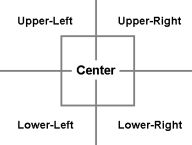
Position of the label around the coordinate:
0 = upper right
1 = upper left
2 = lower left
3 = lower right
4 = center
Radio Mobile comes with a file holding cities from all over the world. This file 'cities.dat' can be used to store units.
The file is in the following format:
| Labels.dat |
|---|
|
Radio Mobile Labels ... <icon_number>,<latitude>,<longitude>,<name>,<name>,<label_position>,<color> |
The file starts with the identifier to Radio Mobile that this is a label file.
| Variable | Comment |
|---|---|
| icon number | number if the icon |
| latitude | latititude in degrees.decimal-degrees |
| Longitude | longitude in degrees.decimal-degrees |
| name | name of the city or object |
| label position |
Position of the label around the coordinate: 0 = upper right
|
| color | color in hex as described in 'general functions > color' |
Here a part of a sample labels.dat file:
| Labels.dat |
|---|
| Radio Mobile Labels 0,52.060368,4.303653,s-Gravenhage,4,-1 0,51.697707,5.310099,s-Hertogenbosch,4,-1 0,52.261549,4.759505,Aalsmeer,4,-1 0,52.633872,4.745189,Alkmaar,4,-1 0,52.360774,6.664602,Almelo,4,-1 0,52.37059,5.213805,Almere,4,-1 0,52.133024,4.665712,Alphen Aan Den Rijn,4,-1 0,52.155484,5.377941,Amersfoort,4,-1 0,52.308454,4.864911,Amstelveen,4,-1 0,52.373848,4.902081,Amsterdam,4,-1 0,52.309694,4.959023,Amsterdam Zuidoost,4,-1 0,52.211286,5.96133,Apeldoorn,1,-1 0,51.989997,5.926301,Arnhem,3,-1 |