|
This item describes some characteristics of Clutter and the land cover data. Also it goes in some detail regarding the implementation of Land Cover in Radio Mobile. It enables the reader to determine what is best for his situation.
Land cover data as it is made available by the University of Maryland is evaluated on:
- Accuracy compared to knowledge of the reference area by the author.
- Correlation to generally known
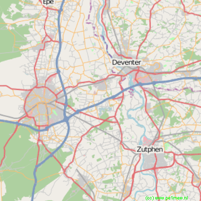
The reference area is in the middle of the Netherlands and cover 3 main cities: Apeldoorn, Deventer, and Zutphen. This area is known as 'Steden driehoek' or SDH.
 SDH Area SDH Area
This area holds 'Urban area' from which the centre of Deventer and Zutphen hold 'Dense Urban Area's'. The land als holds forest and agricultural grounds that can be populated by scattered bushes and woods. This a typical river land as can be found in Holland.
To be able to determine accuracy of the Land Cover data, polygons and lines are drawn in Radio Mobile around 3 main areas: City's Apeldoorn and Deventer and a small forest. The pink line (highways A1 and A50) and the blue line (river IJssel) are drawn for orienteering purposes.
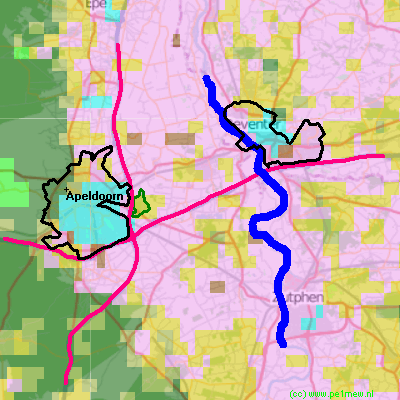
In this image the following layers are displayed (from top to bottom)
- Objects
- Land Cover
- Open Street map
It can be clearly seen that 'Urban and Build-up' (light blue) does correlate to the city of Apeldoorn and both other cities. However the area that is described as 'Urban and Build-up' is much smaller than the polygon that represents the city's. A reason for this might be that residential areas who commonly are located on the edge of the urban areas are identified as Rural areas.
Also it can be seen that the forest area (green polygon) is not identified as 'Forest' but as 'Woodland'. This might be influenced by the dominance of the surrounding 'Crop land'.
Conclusion.
Land Cover does not have the level of detail that is required for radio planning on a regional scale. However it can enhance the accuracy of the RF predictions when used properly. See 'How to > Land Cover'
|
