Folder object06
Version 900
Frequency 169-170 MHz
Fixed Unit:
Arendsburgt @ 37 meters 25 Watt +42 dBm Erp using dipole + 2 dB cable loss
Mobile unit:
mobile @ 1 m RX sensitivity -120 + 2 dB cable loss
Model settings:
SR 300 N
GC 0,005 S/m
RGP 15
Martime temperate over land
Variablility: Spot 75%
Use 'Two rays' for line of sight: YES / Normal
Landcover ON
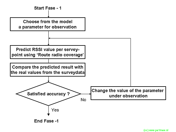
Step Height Forest Height City File Average error Stdev
1 Default RouteResult06_01.xls 16,8 6,2
Step Height Forest Height City File Average error Stdev
2 0 50 10 100 RouteResult_02.txt 17,8 6,2
3 0 100 10 100 RouteResult_03.txt 17,8 6,2
4 1 100 10 100 RouteResult_04.txt 12,5 5,5
5 1 200 10 100 RouteResult_05.txt 7,1 5,0
6 1 300 10 100 RouteResult_06.txt 1,8 4,7
7 1 400 10 100 RouteResult_07.txt -3,4 4,5
8 1 500 10 100 RouteResult_08.txt -8,7 4,7
Use 'Two rays' for line of sight: YES / Interference
Step Height Forest Height City File Average error Stdev
9 1 300 10 100 RouteResult_09.txt 2,29 4,3
Use 'Two rays' for line of sight: NO
Step Height Forest Height City File Average error Stdev
10 1 300 10 100 RouteResult_10.txt 2,19 4,3
Moved to object08
New route through urban and forest
Use 'Two rays' for line of sight: NO
Step Height Forest Height City File Average error Stdev
11 1 300 10 100 RouteResult_11.txt 3,5 4,9
Use 'Two rays' for line of sight: NO
Step Height Forest Height City File Average error Stdev Urban Forest Combined
12 1 300 1 200 RouteResult_12.txt 0,06 5,2 13,63 9,52 -1,734
Use 'Two rays' for line of sight: Interference
Step Height Forest Height City File Average error Stdev Urban Forest Combined
13 1 300 1 200 RouteResult_13.txt 0,08 5,2 13,63 9,52 -1,734
Changed bare ground and grassland and cropland to 1 m 1%
Step Height Forest Height City File Average error Stdev Urban Forest Combined
14 1 300 1 200 RouteResult_13.txt 0,08 5,2 13,63 9,52 -1,734
Changed bare ground and grassland, cropland, Open Shrubland to 1 m 1%
Step Height Forest Height City File Average error Stdev Urban Forest Combined
14 1 300 1 200 RouteResult_13.txt 3,08 6,17 13,63 4,93 2,48
|