|
Radio Mobile - RF propagation simulation software |
|
|
|
|
|
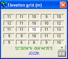
Opens a small window that shows 5x5 elevation data records centred at cursor position along with cursor coordinates.
If you click on the  button the elevation grid is expanded and the area over which the elevation grid is reporting is displayed. button the elevation grid is expanded and the area over which the elevation grid is reporting is displayed.
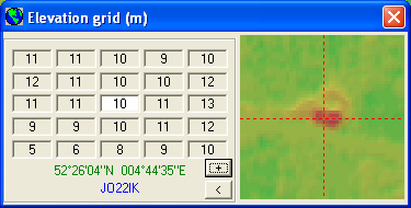
The  button reduces the elevation grid to it's original size. button reduces the elevation grid to it's original size.
- In green the location is displayed in the native coordinate system of Radio Mobile.
- In blue the user selectable coordinate system is displayed. This coordinate system can be selected in 'coordinates'
The  button moves the cursor to the centre of the map view. button moves the cursor to the centre of the map view.
|
|
| |
|
|
cmsimple-styles.com template modified by PE1MEW |
