|
SRTM data is by far the most popular data set that Radio Mobile can use.
 The Shuttle Radar Topography Mission (SRTM) obtained elevation data on a near-global scale to generate the most complete high-resolution digital topographic database of Earth. SRTM consisted of a specially modified radar system that flew on-board the Space Shuttle Endeavour during an 11-day mission in February of 2000. The Shuttle Radar Topography Mission (SRTM) obtained elevation data on a near-global scale to generate the most complete high-resolution digital topographic database of Earth. SRTM consisted of a specially modified radar system that flew on-board the Space Shuttle Endeavour during an 11-day mission in February of 2000.
SRTM is an international project spearheaded by the National Geospatial-Intelligence Agency (NGA) and the National Aeronautics and Space Administration (NASA).
More information on SRTM can be found at the The Shuttle Radar Topography Mission web page or Shuttle Radar Topography Mission elevation data.
SRTM data is available in 2 qualities:
- 3 arc second data 90 x 90 meters, Global
- 1 arc second data 30 x 30 meter, USA only.
The 3 arc second data is public to the world as well as the USA 1 arc scond data is. The 1 arc second data outside of the USA is not public available. This is no problem for general RF propagation calculations. More detailed information is required when you want to do RF analysis in Urban areas. This is required for example by cellular network operators.
Covered areas by SRTM
The data generated by the Space Shuttle only covered between 60° N and 59° S as can be seen on the following image. 0.2 % of the world was not mapped by the SRTM mission.
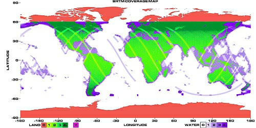
Click on the image for a full size version.
The missing areas are filled in by projects like the one from Jonathan de Ferranti.
See: http://www.viewfinderpanoramas.org/topog.html
SRTM V2
Initially SRTM became available in release '1' This first release had some flaws. The current, enhanced release, release '2' has improved significantly:
NASA has released version 2 of the Shuttle Radar Topography Mission digital topographic data (also known as the "finished" version). Version 2 is the result of a substantial editing effort by the National Geospatial Intelligence Agency and exhibits well-defined water bodies and coastlines and the absence of spikes and wells (single pixel errors), although some areas of missing data ('voids') are still present
Disadvantage of the obtained radar images is that snowed mountain tops disturbe the radar image. This causes mayor flaws in the SRTM data.
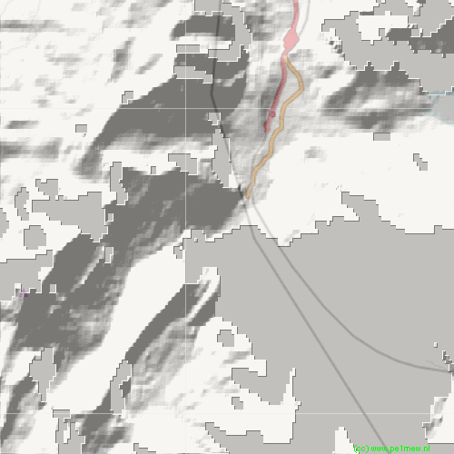
SRTM V2 data of the Kandersteg area in Switzerland. The Gray areas are errored.
To overcome this problem additional height databases are merged with the SRTM data.
A practical solution for a part of the European area is offered by Radio Mobile as a special data-set you can access from the internet. In this dataset a 'Corrected SRTM data set' is offered. Here the work is already done and the errors in the original SRTM data is corrected.
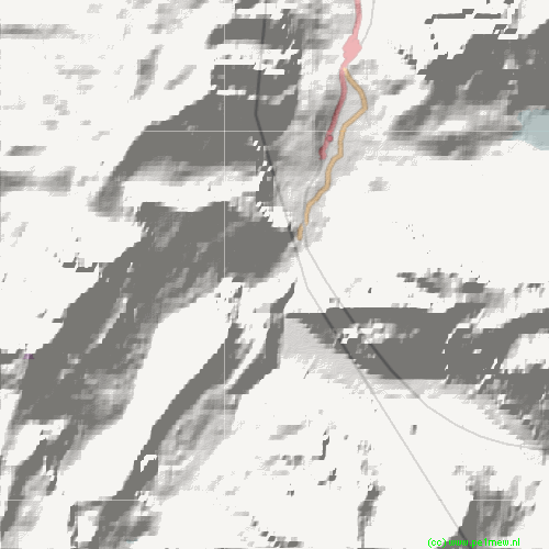
Corrected SRTM V2 data from the Kandersteg area in Switzerland.
The data is downloaded from http://srtm.sjti.de/hgt/ which is configurable in 'Options > Internet: SRTM'
The available corrected data is displayed in the following image.
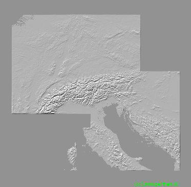
As can be seen this corrected dataset does not cover all of Europe so it has to replace the original SRTM V2 data when available. To solve this Radio Mobile can handle multiple DEM sources.
How to do this is discribed in 'How to > Work with geodata > use multiple DEM sources'
SRTM V3
SRTM data is also available in as "V3" from http://srtm.csi.cgiar.org/
THE SRTM DATA NOW AVAILABLE FROM http://srtm.csi.cgiar.org/ HAS BEEN UPGRADED TO VERSION 3. THIS LATEST VERSION REPRESENTS A SIGNIFICANT IMPROVEMENT FROM PREVIOUS VERSIONS DUE TO USE OF USGS “FINISHED” GRADE DATA, FURTHER OPTIMISATION OF THE HOLE FILLING ALGORITHM AND THE USE OF AUXILIARY DEMs FOR FILLING IN THE HOLES. FURTHER INFORMATION IS AVAILABLE ON THE METHODS PAGE.
At this moment it is not possible to automatically configure Radio Mobile to use this source.
###
|

