|
In this example a list of points in NMEA datagrams is converted in to a line object file for Radio Mobile. The method in which this is done is transparent for all kind of data.
 In this example some images are shown from Excel. The version of Excel displayed is in Dutch. Therefore some texts are in Dutch and not in English. In this example some images are shown from Excel. The version of Excel displayed is in Dutch. Therefore some texts are in Dutch and not in English.
1. Import NMEA data in to Excel.
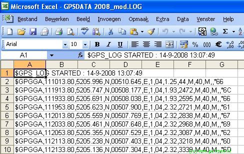
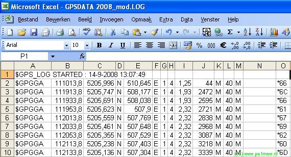
- The log file that holds the NMEA data is imported in to Excel;
- Convert the lines in to coloumns:
Use 'separated'
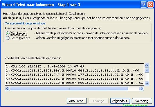
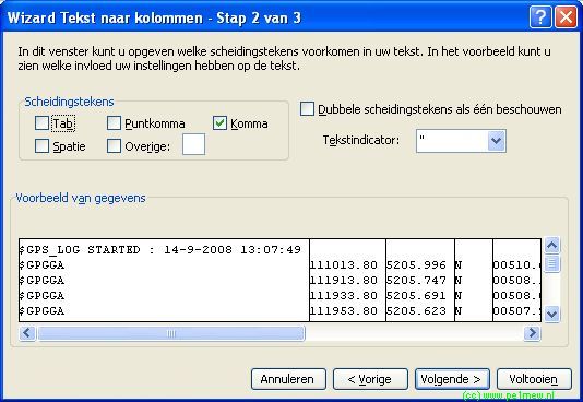
- And use 'Comma' as a separation character.
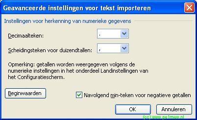
 If you are working in a non English oriented country you might want take precautions on the decimal sign and separation sign for thousands. If you are working in a non English oriented country you might want take precautions on the decimal sign and separation sign for thousands.
Before finishing click 'Advanced' and set the decimal sign to '.' and separation sign for thousands to ','.
- Now the import is completed and the result will be similar to the image shown below.
2.Extract coordinates and prepare the data for further use.
To understand the syntax of the NMEA datagram we will use the following description of the GGA datagram:
GGA Displays essential fix data which provide 3D location and accuracy data.
$GPGGA,123519,4807.038,N,01131.000,E,1,08,0.9,545.4,M,46.9,M,,*47
Where:
| GGA |
Global Positioning System Fix Data |
| 123519 |
Fix taken at 12:35:19 UTC |
| 4807.038,N |
Latitude 48 deg 07.038' North |
| 01131.000,E |
Longitude 11 deg 31.000' East |
| 1 |
Fix quality:
0 = invalid
1 = GPS fix (SPS)
2 = DGPS fix
3 = PPS fix
4 = Real Time Kinematic
5 = Float RTK
6 = estimated (dead reckoning) (2.3 feature)
7 = Manual input mode
8 = Simulation mode |
| 08 |
Number of satellites being tracked |
| 0.9 |
Horizontal dilution of position |
| 545.4,M |
Altitude, Meters, above mean sea level |
| 46.9,M |
Height of geoid (mean sea level) above WGS84
ellipsoid |
| (empty field) |
time in seconds since last DGPS update |
| (empty field) |
DGPS station ID number |
| *47 |
the checksum data, always begins with * |
If the height of geoid is missing then the altitude should be suspect. Some non-standard implementations report altitude with respect to the ellipsoid rather than geoid altitude. Some units do not report negative altitudes at all. This is the only sentence that reports altitude.
In our import column C,D,E, and F hold the coordinates of the points. However we have to transform these in to a format that Radio Mobile can use in the Ozi Explorer '.plt' format
- We skip the N,E,S,W as these are not required for this conversion
- The GGA data has latitude and longitude information in 'degrees, minutes-decimal minutes' combined in to one field. The Ozi Explorer .plt format requires latitude and longitude in 'degrees-decimal degrees' Therefore we have to convert the latitude and longitude informtation.
The first step is to split the latitude field in the GGA datagram in to the degrees- and the minutes part. To perform this action we use the following functions in Excel:
Latitude
- First we take the left 2 numbers from the latitude string that form the degrees, this is '52' degrees.
- Second we take the the minutes-decimal minutes numbers, this is '05,996' minutes.
- Third we convert the minutes to degrees. There fore the minutes-decimal mintes are devided by 60 minutes as one degree is 60 minutes.
- Fourth and last step is to add the in dergees expressed minutes-decimal minutes to the other dergees.
This function is caputered in the following Excel formula:
=LEFT(C2;2)+(RIGHT(C2;(LENGTH(C2)-2))/60)
Longitude
- First we take the firste left number from the longitude string that form the degrees, this is '5' degrees.
- Second we take the the minutes-decimal minutes numbers, this is '10,645' minutes.
- Third we convert the minutes to degrees. There fore the minutes-decimal mintes are devided by 60 minutes as one degree is 60 minutes.
- Fourth and last step is to add the in dergees expressed minutes-decimal minutes to the other dergees.
This function is caputered in the following Excel formula:
=LEFT(E2;1)+(RIGHT(E2;(LENGTH(E2)-1))/60)
The result of this coversion can be downloaded:
3 - Create the line object file.
- First we create a ASCII text file with a name that represents the data we are processing. The file name formatting is described in 'How to > Work with objects' in our case the file name will be: 'L1X-Ballon.plt'
- Second We copy the header in to the file. The example is displayed below.
OziExplorer Track Point File Version 2.1
WGS 84
Altitude is in metre
Reserved 3
0,2,16711935,14-9-2008 13:07:49
156 |
- Third change the date-field to the correct data. In our case it is '14-9-2008 13:07:49'.
- Fourth change the 'records' field to the number of points that will be imported in to the line object file.
- Fifth and last is to copy the prepared data form Excel in to the lineobject file.
Be aware that Excel copies [TAB] as a separator and the '.plt' file format requires a [,] (comma) as a separator. To display the effect the following fiels shows a raw copy from Excel to ASCII tekst in Notepad:
52,0999 5,1774 0 44
52,0958 5,1363 0 2472
52,0949 5,1340 0 2595
52,0937 5,1317 0 2721 |
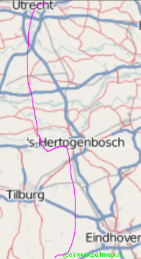
When the tabs have been replaced and the decimal sign is converted from [,] to a [.] (Dutch in to English) the conversion is complete.Now the line object file is complete and can be used in Radio Mobile:
OziExplorer Track Point File Version 2.1
WGS 84
Altitude is in metre
Reserved 3
0,2,16711935,14-9-2008 13:07:49
156
52.09993,5.17742,0,44
52.09578,5.13628,0,2472
52.09485,5.13397,0,2595
52.09372,5.13167,0,2721 |
|

 Balloon2008_GPSDATA.xls