|
Radio Mobile - RF propagation simulation software |
|
|
|
|
|
Antenna height above average terrain, along with the FM and TV propagation curves is commonly used in the prediction of coverage by television stations and by FM radio stations as well as some wireless radio services. FM and TV coverage may be extended or shortened in a given direction depending on the terrain in that direction.
For example, a mountain may reduce service (as compared to flat terrain), while a valley may allow expanded coverage.
The HAAT value represents an average of the terrain elevations within 16 km (10 miles) of the transmitter site, and so provides a single value on which general coverage calculations and regulatory requirements (such as station classes) may be based.
How is the HAAT determined?
A HAAT value is determined by taking 50 evenly spaced elevation points (above mean sea level [AMSL]) along at least 8 evenly spaced radials from the transmitter site (starting at 0 degrees [True North]). The 50 evenly spaced points are sampled in the segment between 3 to 16 km (formerly 2 to 10 miles) along each radial. The elevation points along each radial are averaged, then the radial averages are averaged to provide the final HAAT value. Terrain variations within 3 km (2 miles) of the transmitter site usually do not have a great impact on station coverage.
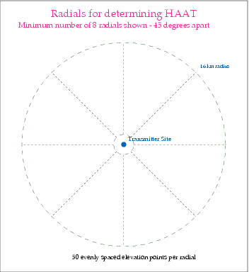
Only the 3 to 16 km segment of each radial is used.
When the concept of antenna height above average terrain was developed in the late 1930s and 1940s for VHF and UHF radio and television, the process for determining HAAT was a manual one. An engineer would lay out topographical maps covering a radius of 10 miles from the transmitter site, draw 8 radials spaced every 45 degrees, and then find the elevations for 50 evenly spaced points out to 10 miles from the transmitter site for each radial, and then average the points for each radial between 2 and 10 miles from the transmitter site. Needless to say, this procedure was very tedious. In 1984, it was formally permitted to applicants to use terrain databases in the computation of HAAT, and permitted applicants to use additional evenly spaced radials.
|
|
| |
|
|
cmsimple-styles.com template modified by PE1MEW |
