|
Locator systems were developed in Europe primarily to permit Amateur Radio operators to measure the distance they were able to communicate on VHF frequencies. Prior to this they were using standard Geodetics (longitude and latitudes) but all those numbers were difficult to transmit and receive on both voice and CW.
By the mid-seventies there was sufficient interest world wide to develop a system that could be used in all regions and at one time there were more than 20 systems being considered. Finally, in 1980 in Maidenhead, near London, at a VHF working-group meeting, it was decided to adopt a single system that could be used world wide and this system became known as the Maidenhead System or simply "the locator". A more common name for the maidenhead locator system and probably more recognisable is grid square.
A grid square measures 1 degree latitude by 2 degrees longitude and measures approximately 70 x 100 miles in the continental US. A grid square is indicated by two letters (the field) and two numbers (the square). Maidenhead grid squares or simply grid squares represent a position on the earth based on latitude and longitude. The world is first divided into 324 large areas. These areas cover 10 degrees of latitude by 20 degrees of longitude and are called fields. Each field is divided into 100 squares, this is where the name grid squares come from, each of these 100 squares represent 1 degree by 2 degrees, this gets us the EL29 which is what most people will exchange.
The Locator represents a position on the Earth based on latitude and longitude. The system deliberately limits the precision so that a minimum number of characters are needed to describe a position using voice or Morse code.
Technical description
Unlike the conventional system of Latitude/Longitude (Geodetics), the Locator System begins at the South Pole at the Prime Meridian (180o or the International Dateline), and builds Northward and Eastward ending back at the Prime Meridian at the North Pole, but on the East (opposite) side of the dateline.
The first grid square is AA00aa (probably not many stations there) and the last grid square is RR99xx (also sparsely populated)
By definition each "Field" which is represented by the first two letters is 20 degrees wide by 10 degrees high. At the equator, therefore, each Field, is about 1,380 miles wide. Since there are 18 of them they are identified as A through R. At our latitude, each Field is closer to 1000 miles wide and up at latitude 49 (the Canadian border) they are about 990 miles wide. Nearing the Poles, the Fields are triangular, being approximately 250 miles wide along the 80th parallel and tapering to a point at the exact center of the Pole. The Fields are all approximately the same "height" (distance from South to North) about 690 miles.
The first alpha character represents the longitude and the second alpha character represents the latitude. For example, we are in Field CM. "C" begins West of us at 140oW and changes to "D" just 2o East of us at 120o, just West of Reno. "M" is our latitude. Every Field between 30o and 40o N will have "M" as the second Alpha designator.
Each of the 324 Fields which cover the surface of the earth are subdivided into 100 squares, each of which is 1o of Latitude and 2o degrees of Longitude. These squares are numbered 00 through 99 using the same pattern as the Field, i.e. the lower left corner upward and to the right. Here is the layout of the numbering of the squares within any Field:
| 09 |
19 |
28 |
39 |
49 |
59 |
69 |
79 |
89 |
99 |
| 08 |
18 |
28 |
38 |
48 |
58 |
68 |
78 |
88 |
98 |
| 07 |
17 |
27 |
37 |
47 |
57 |
67 |
77 |
87 |
97 |
| 06 |
16 |
26 |
36 |
46 |
56 |
66 |
76 |
86 |
96 |
| 05 |
15 |
25 |
35 |
45 |
55 |
65 |
75 |
85 |
95 |
| 04 |
14 |
24 |
34 |
44 |
54 |
64 |
74 |
84 |
94 |
| 03 |
13 |
23 |
33 |
43 |
53 |
63 |
73 |
83 |
93 |
| 02 |
12 |
22 |
32 |
42 |
52 |
62 |
72 |
82 |
92 |
| 01 |
11 |
21 |
31 |
41 |
51 |
61 |
71 |
81 |
91 |
| 00 |
10 |
20 |
30 |
40 |
50 |
60 |
70 |
80 |
90 |
Since the Fields at our Latitude are nearly 1,000 miles wide, each square is about 100 miles wide
For additional precision, each of the above Squares is divided into "Sub-squares" using identifiers aa through xx. In the US and UK, These identifiers are shown in lower case although you will see many examples using upper case. Here is a portion of a Square, divided into Sub-squares. Only the lower left corner is shown for brevity.
| ad |
bd |
cd |
dd |
| ac |
bc |
cc |
dc |
| ab |
bb |
cb |
db |
| aa |
ba |
ca |
da |
Each Square is divided into 576 Sub squares (24x24) each of which is 2.5 minutes longitude and 5 minutes latitude. At our latitude this equates to about 4.2 miles wide. The entire system is devised so that no sub square is more than 12 km or 7.2 miles from one corner to the other diagonally. Grid squares are used extensively in microwave communication and measurements are made using the center of the square or sub-square.
If additional precision is required, the sub-squares can also be divided and then those sub-sub-squares can also be divided. The protocol requires using alternating pairs of Alpha-numerics. For the purposes of Amateur Radio however, 3 pairs of characters work quite well. To add more precision one might be better off just using Geodetics.
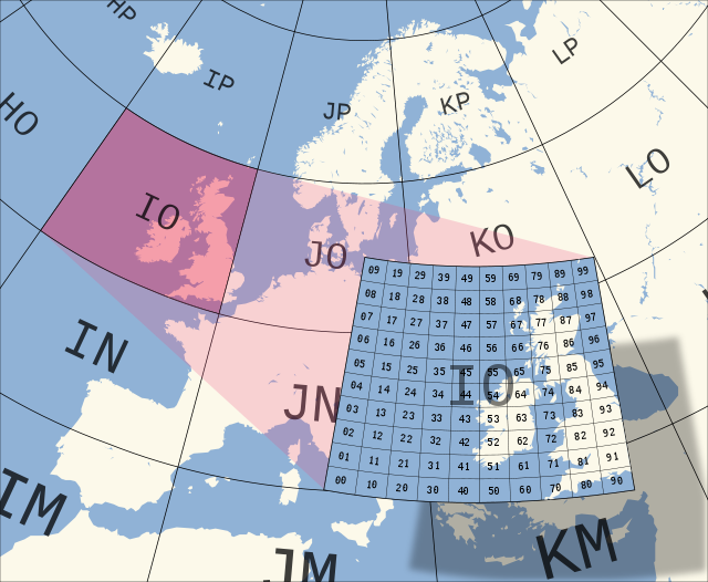
Image source: Wikipeadia (http://en.wikipedia.org/wiki/Maidenhead_Locator_System)
|
