|
Radio Mobile - RF propagation simulation software |
|
|
|
|
|
Opens a form in order to set preferences for elevation data useage. Here selection is made on how to use elevation data:
- Elevation data extraction method that will be used in Radio Link and Network performance.
- Land cover data settings that will be used in propagation prediction.
Radio Mobile can use multiple elevation height database in a single simulation. For example when high resolution elevation data is available over small areas or with gaps. At data options you can either select the settings from the 'Map properties' menu or override them.
Use elevation data in memory generated bij Map Properties.
Using this option the settings from the 'Map properties' menu are used. See 'File > Map Properties'
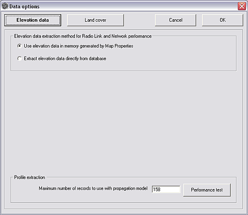
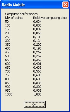
Profile extraction
Set the number of record to use with propagation model.
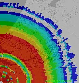
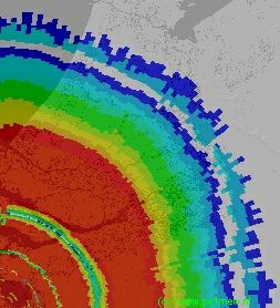
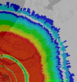
The number of records are the number of points between the TX and the RX unit that are taken in account in a simulation. More points will result in a higher accuracy an will take a long time to calculate. Less points will have a low accuracy but require a short calculation time.
In RF prediction a balance is required between calculation time and the accuracy.
The following images display the effect on the result using 158, 500, and 1000 points.
Performance test
Displays the power of the PC that runs Radio Mobile. It gives a estimate of the to be expected time for a simulation run.
Extract elevation data directly from the database.
Using this setting the settings from the 'Map properties' menu are overrided.
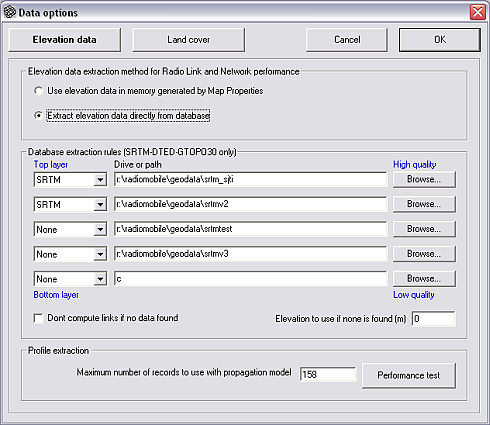
Database extraction rules (SRTM-DETED-GTOPO30 only)
Here the order in which height data sources are being used is set. The top layer will carry the highest quality of data and the botom layer will carry the lowest quality of data.
1st box: Data type
here the data type is selected. possible sources are:
Drive or path
the path to the directory that contains the data
Don't compute links if no data found
If checked the radiolink is not computed over the area that has no data available.
Elevation to use if non is found (m)
The ground height that shoul be used when no data is available in meters.
A example of this case is given at 'geodata > SRTM'
|
|
| |
|
|
cmsimple-styles.com template modified by PE1MEW |
