|
 This function can be called by the [F8] key This function can be called by the [F8] key
Opens a form in order to define the map coverage boundaries and select the elevation database (see 'How to obtain geodata').
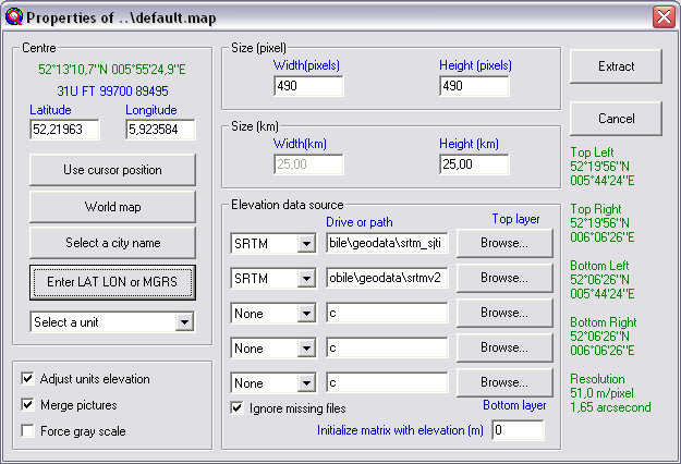
Centre
This applies to the centre of the active map window.
On top of the centre part of the menu is displayed:
- coordinates of the center of the window is displayed in latitude-longitude (degrees, minutes, decimal-seconds, N/S/E/W)
- Maidenhead locator
Use cursor position
The active map window we are about to draw is centred on the last coordinate a map was draw. By using this function the new map is drawn centred on the coordinate that the cursor was put before.
World map
Select the centre of the new map window by clicking on the world map.
Select a city name
The centre of the active window can be selected from the cities.dat file. Select the unit from the cities.dat file on which the centre of the new map window will be drawn.
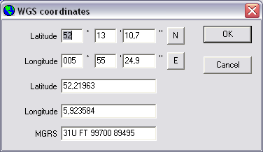
Enter LAT LON or MGRS
Select the centre of the new map window by entering coordinates in latitude-longitude or in MGRS or Maidenhead.
Adjust units elevation
When this function is enabled the ground height of all units in the map window is set to the actual ground heigth at the location of the unit.
Merge pictures
This option forces to open the 'merge pictures' dialogue after the active map window containing height data is finished drawing.
Force gray scale
This option forces the result in the active map window to be redrawn in grey-tones.
Size (pixel)
The new map window dimension is set in pixels. You are free to choose the dimensions. the maximum pixels per edge of the window is 1999 pixels. you will be warned when a value greater than 2000 is set.
Width (pixels)
Number of horizontal pixels of the map window.
Height (pixels)
Number of vertical pixels of the map window.
Size (Km)
Here the kilometres per side of the image is set. Only the height of the map window can be set.
The width is calculated depending on the size of the map window set ast the 'Size'
Elevation data source
Here the source of your elevation data is configured.
The program can access a resolution of 1, 3, or 30 seconds of an arc, which corresponds to a spacing of approximately 30m, 100m, or 1 km between records.
The program can read GTOPO30, GLOBE and DTED level 0 at 30 arc second, SRTM and DTED level 1 at 3 arc second, DTED level 2 and SRTM at 1 arcsecond, and BIL at any resolution
It is possible to configure access to 4 sources at the same time. Depending on the priority, elevation data will be used. The first source to be accessed is the top layer. The bottom layer is accessed the last.
Per layer the source type is selected and the path to the data. Dynamicaly to this configuration in 'Options > Internet' one external source can ben configured.
Ignore missing files.
when required elevation tiles are not available at the location here it can be set to ignore these files and continue.
|
