|
This menu enables to configure the geocoding information for a raster image. Radio Mobile supports BMP, JPEG, GIF, TIFF, and PNG.
The process of geocoding a picture is described in 'How to > Work with geodata > Geocode raster images'.
Cancel
Ends current activities without saving the changes. Closes the window.
OK
Save thanges and ends activities. Closes the window.
Datasource
This is a 'comment field' and can be any information. The comment is stored in the 'mapfile.dat' file that is associated with the custom picture.
Four courners method
Using this method it is possible to geocode non-rectacular pictures.
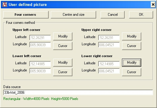
Corners (upper lef, upper right, lower left, lower right)
Coordinate of the associated corner in Latitude Longitude. Latitude and Longitude are in the format 'degrees.decimal-degrees' with map date 'WGS84'
Modify
Here the coordinates from each corner of a image is displayed. Using 'modify' the coordinates can be changed per Latitude and Longitude.
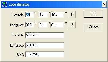
After 'modify' a window is displayed where the precise coordinates can be entered.
- QRA is global and not accurate enough.
- Latitude and Longitude in the format 'degrees.decimal-degrees' are automatically converted in to 'degrees, minutes, seconds, N/E/S/W' by Radio Mobile.
Cursor
When the coordinates are unknown the active cursor coordinates can be copied in to the Latitude Longitude fields.
Centre and size
Using this method it is possible to geocode non-rectacular pictures.
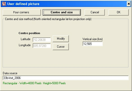
Centre position
Coordinate of the centre position in Latitude Longitude. Latitude and Longitude are in the format 'degrees.decimal-degrees' with map date 'WGS84'
Modify
Here the coordinates of the centre of a image is displayed. Using 'modify' the coordinates can be changed per Latitude and Longitude.
The centre of the picture is at 1/2 width (pixels), 1/2 height (pixels).
After 'modify' a window is displayed where the precise coordinates can be entered.
- QRA is global and not accurate enough.
- Latitude and Longitude in the format 'degrees.decimal-degrees' are automatically converted in to 'degrees, minutes, seconds, N/E/S/W' by Radio Mobile.
Cursor
When the coordinates are unknown the active cursor coordinates can be copied in to the Latitude Longitude fields.
Vertical size (Km)
This is the length in Kilometers covered by the height of the picture.
|