|
Landcover data can be used from two sources. The first source is a local landcover file. The second is a datasource on the internet. The source is selected by the "IMG" or "LCV" Check boxes.
This button enables you to toggle Land Cover usage ON or OFF. To display the status
- Green
 represents ON, represents ON,
- Red
 represents OFF. represents OFF.
Land Cover in Elevation data
Here all individual clutter classes can be set as available in land cover.
These individual parameters are described in 'How to > Land cover'
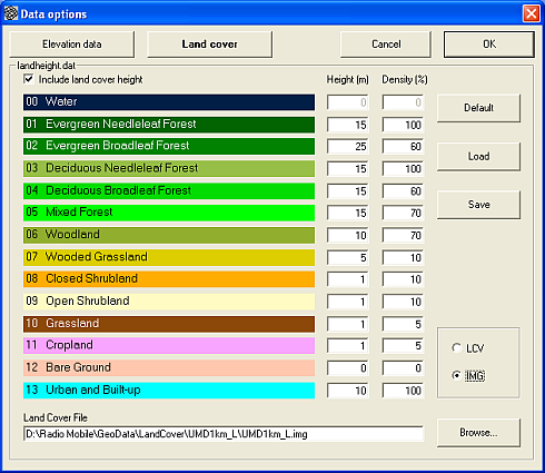
Landheight.dat
Include land cover height.
Enables to add clutter height to the ground height in the prediction model.
See also 'Terrain data > Background on DEM' for additional information on this setting.
When this is checked clutter information is also displays in the Status bar (see 'View > Statusbar')
The results can be seen in 'Tools > Radio link'
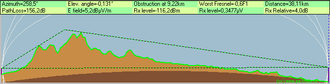
This is a example without clutter

This is a example with clutter
Clutter classes
These are the clutter classes. They are displayed with default height and density.
The given values are applicable to the data set that is downloadable form the university of Maryland's but may change when using other data sets.
| |
Clutter class |
Height (m) |
density (m) |
| 00 |
Water |
0 |
0 |
| 01 |
Evergreen Needleleaf Forest |
5 |
100 |
| 02 |
Evergreen Broadleaf Forest |
15 |
60 |
| 03 |
Decidious Needleleaf Forest |
3 |
100 |
| 04 |
Decidious Needleleaf Forest |
8 |
60 |
| 05 |
Decidious Broadleaf Forest |
10 |
70 |
| 06 |
Mixed Forest |
5 |
70 |
| 07 |
Wooded Grassland |
4 |
10 |
| 08 |
Closed Shrubland |
2 |
10 |
| 09 |
09 Open Shrubland |
1 |
10 |
| 10 |
Grassland |
1 |
5 |
| 11 |
Cropland |
1 |
5 |
| 12 |
Bage Ground |
0 |
0 |
| 13 |
Urban and Build-up |
10 |
100 |
| |
|
|
|
Land cover file
Points to the folder where the landcover file "landcover.img" or the landcover files in ".lcv" are located. See 'Configure landcover usage'.
Height (m)
The average height of this type of clutter. For more information seel 'Land Cover'
Density (%)
The density of the clutter for radio waves. For more information seel 'Land Cover'
Default
Sets default values from Radio Mobile
Load
Loads a pre-set for both clutter height and density from file. The file format is described in 'File formats > Landcover.dat format'
Save
Stores the current settings for late use. Both clutter height and density are stored. The file format is described in 'File formats > Landcover.dat format'
Configure landcover source
The first source is a local land cover image-file. The second is a data source on the internet.
The source is selected by the "IMG" or "LCV" Check boxes.
.IMG image file
This data covers the area of your choice. The landcover image file covers the world in 1 Km grid.
 While using the local stored image file select the "IMG" Checkbox. Copy the "landcover.img" file in a folder called 'landcover'. Set the path to that folder holds the landcover file in 'Options > Data options > Land cover'. Select the file 'landcover.img'. While using the local stored image file select the "IMG" Checkbox. Copy the "landcover.img" file in a folder called 'landcover'. Set the path to that folder holds the landcover file in 'Options > Data options > Land cover'. Select the file 'landcover.img'.
.LCV files
The .lcv that is offered using the Radio Mobile download service is only providing land cover data for North America and Canada.
To enable the use of LCV files from the internet select the "LCV" checkbox.
Set the path to the landcover file in .LCV format to the same path as the path configured in 'Options > Internet > Landcover'

|
