|
This is a example of Land cover verification as I performed for my area. The results are applicable to typical Netherlands area's such as forests (veluwe), Urban areas (general cities like Apeldoorn. Not for Amstedam, Rotterdam and Utrecht!) and general agricultural areas. The results of this verification might work good in your area but you are strongly adviced to perform a verification of your own.
Before you can do a verification survey data has to be processed and ready for useage. Collecting data is described in 'Test site' and 'Survey vehicle'. Post processing survey data is described in 'Survey data'. The objective of this verifictaion was to determine the factors for the clutter types used in Land Cover.
Settings
The ITM model does not leave us many parameters to set, but in this example where we intend to modify specific parameters we will do change a number of parameters. In this example the mode of variability is choosen to be 'spot'. It is subject of discussion on which variability to use. I have been succesfully using 'Mobile' over the past years. The mode of variability is described in 'ITM model propagation settings'. The following settings (which are applicable to the Netherlands) have been used:
Parameters:
- min Frequency: 169 MHz
- max Frequency:170 MHz
- Polarisation: Vertical
- Mode of availability: Spot
- % of situations: 70%
- Surface refractivity: 301 N-Units
- Ground conductivity: 0,005 S/m
- Relative ground permitivity: 15
- Climate Maritime temperate over land.
Test site:
- Transmit power: 25 Watt (+ 44 dBm)
- Line loss: 1 dB
- Omni antenna
- Antenna gain: 3 dBi
- Antenna height: 45 meter
Survey Vehicle:
- receiver treshold: 0,229 uV (-120 dBm)
- Line loss: 1 dB
- Antenna gain: 0 dBd
- Antenna height: 2 meter
Objective
The objective is to determine the correction factors for clutter used in Land Cover and have the minimum average error.
Terrain selection.
Because the Land Cover implementation in Radio Mobile affects the forest and urban correction factors in the ITM model all the clutter classes in Land Cover are cobined in to 3 classes:
'Flat Clutter':
00 Water
Forest:
01 Evergreen Needleleaf Forest
02 Evergreen Broadleaf Forest
03 Decidious Needleleaf Forest
04 Decidious Broadleaf Forest
05 Mixed Forest
06 Woodland
07 Wooded Grassland
08 Closed Shrubland
09 Open Shrubland
10 Grassland
11 Cropland
12 Bage Ground
Urban:
13 Urban and Build-up
It is arbitrary to have classes 09, 10, an 11 not added to 'flat clutter' but this is subject of further investigation.
Verification steps
- The first step is to select parts of the survey route where the radio path from the test site to the survey vehicle is only covering forest areas.
- In the second step parts of the survey data are selected where the radio path only covers Urban areas.
- The third step covers radio paths where a combination of urban and forest clutter is under the radio path.
Selecting points out of the survey data
To determine if and how much of the radio path is going over specific clutter the 'Route radio coverage result file' is examined. This file holds coloumns that expresses the attenauation in dB per clutter type (Forest and Urban). From this information we can select wich survey points have to be used for a 'forest only - radio path'.
The following image displays the result of the analysis. In this graph the black line displays what the composition is of clutter under the radio path. 1=Exclusive Urban, 0=Mixed Urban/Forest, and -1 is exclusive Forest.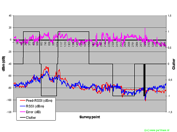
The file in wich this graph is created is available for download: 'Survey analysis of Land Cover'
Now we can select per clutter type the survey points that have a radio path with the required clutter underneath the path.
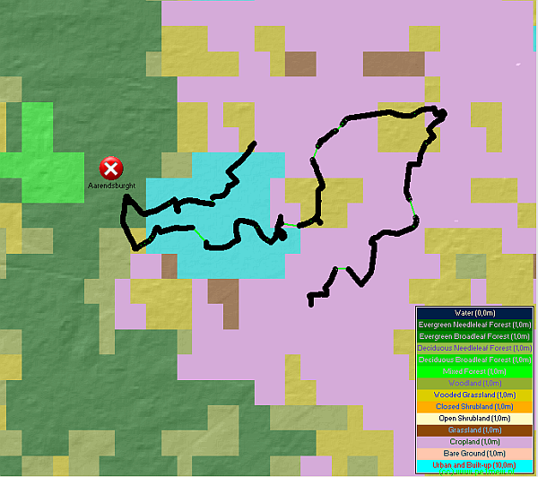
The following 2 images displays the survey routes used. The first only has forest involved, the second has both urban and forest involved.

Forest only
Urban and Forest
Results.
To determine the correct density factors, in all fases the iterative process as described in 'Model analysis' is used.
Clutter height:
Because of the used DEM (SRTM) the hight of the clutter is set to 1 meter above ground level. This is because the land height in SRTM includes clutter height.
Fase 1: Forest.
All clutter classes that are combined to forest are set at the same hight and density. The best results are obtained when Forest density is set to 300%
Fase 2: Urban.
All clutter classes that are combined to forest are set at 1 meter hight and density of 300%. The Urban clutter height is set to 1 meter. The best results are obtained when Urban density is set to 200%
Line of sight settings.
In Adition to the clutter verification the line of sight setting has been altered. The best results are obtained using "Use 'Two rays' for line of sight: NO" or "Use 'Two rays' for line of sight: Interference" where the "Use 'Two rays' for line of sight: Interference" produces 0,01 dB worse average error. This will not be observed in reality so it is preferred to use the "Use 'Two rays' for line of sight: Interference".
With the final settings the average error is 0,08 dB at a stdev of 5,2 dB.
Best practise settings for VHF frequency's
When Land Cover correction is used in my area the following settings perform best:
| Variable |
value |
| Mode of availability: |
Spot |
| % of situations |
70% |
'Flat Clutter':
00 Water |
Height: 0 m; Density: 0%. |
Urban:
13 Urban and Build-up |
Height: 1 m; Density: 200%. |
Forest:
01 Evergreen Needleleaf Forest
02 Evergreen Broadleaf Forest
03 Decidious Needleleaf Forest
04 Decidious Broadleaf Forest
05 Mixed Forest
06 Woodland
07 Wooded Grassland
08 Closed Shrubland
09 Open Shrubland
10 Grassland
11 Cropland
12 Bage Ground |
Height: 1 m; Density: 300%. |
Urban:
13 Urban and Build-up |
Height: 1 m; Density: 200%. |
This is of coarse in combination with the model settings as mentioned at the beginning.
|
