|
To analyse a RF prediction model and determine the accuracy, a itterative process called model tuning has to be deployed. In this process a number of steps have to be followed and at the end you have tuned the model and you know the accuracy of the model.
This process is applicable all RF propagation models an not only for the model used in Radio Mobile.
The full process is described in a flowchart and references are added to some other topics on this site.
Please be aware that this description is only a global one. In professional model tuning more topics need attention and quality and accuracy are very important.
Preparation fase.
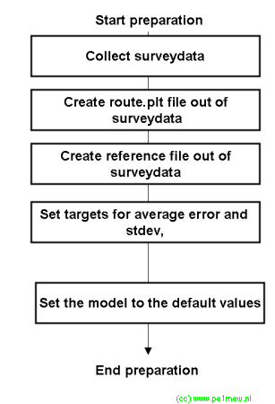 |
- The model tuning starts with collecting survey data. To be 100% accurate, the survey data collection is started by selecting the area over wich you want to tune your model for.
After the survey data collection the data is post prcessed with as a result 2 files:
- The first holds the route file of the survey and contains all positions on wich measurements are performed during the survey. This file must be in the .plt format.
- The secon file holds both locations and values from the survey. This file is used later for comparing calculated results with.
- Now we set our targets on how accurate we want to have our model.
This is the end of the preparation fase. |
Itteration steps.
In the following step one fase out of many is described. This step must be repeated until a satisfying result is reached.
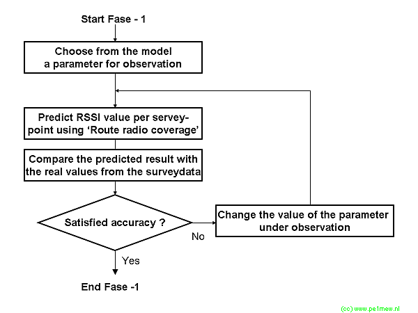
- First we have to decide on wich parameter will be tuned.
- Now we perform a 'Radio route coverage' where the .plt route file from the survey is used.
- The result form the 'Radio route coverage' is exported as a 'Radio route coverage - result file'. This file is imported in to (for example) excel and compared with the measured values from the survey. This process is described as the 'Mathematical verification'
- In this step the result is evaluated. If the result does not satisfy: Based on the observations it is decided to increase of decrease the in step 1 selected value. If the result satisfies, you might decide to select the next variable in the model or finish modeltuning.
It is important to keep a track-log of the steps you have made and the results. For a example I have added the track-log of one of my model tuning exercises:
Track-Notes example.
Folder object06
Version 900
Frequency 169-170 MHz
Fixed Unit:
Arendsburgt @ 37 meters 25 Watt +42 dBm Erp using dipole + 2 dB cable loss
Mobile unit:
mobile @ 1 m RX sensitivity -120 + 2 dB cable loss
Model settings:
SR 300 N
GC 0,005 S/m
RGP 15
Martime temperate over land
Variablility: Spot 75%
Use 'Two rays' for line of sight: YES / Normal
Landcover ON
Step Height Forest Height City File Average error Stdev
1 Default RouteResult06_01.xls 16,8 6,2
Step Height Forest Height City File Average error Stdev
2 0 50 10 100 RouteResult_02.txt 17,8 6,2
3 0 100 10 100 RouteResult_03.txt 17,8 6,2
4 1 100 10 100 RouteResult_04.txt 12,5 5,5
5 1 200 10 100 RouteResult_05.txt 7,1 5,0
6 1 300 10 100 RouteResult_06.txt 1,8 4,7
7 1 400 10 100 RouteResult_07.txt -3,4 4,5
8 1 500 10 100 RouteResult_08.txt -8,7 4,7
Use 'Two rays' for line of sight: YES / Interference
Step Height Forest Height City File Average error Stdev
9 1 300 10 100 RouteResult_09.txt 2,29 4,3
Use 'Two rays' for line of sight: NO
Step Height Forest Height City File Average error Stdev
10 1 300 10 100 RouteResult_10.txt 2,19 4,3
Moved to object08
New route through urban and forest
Use 'Two rays' for line of sight: NO
Step Height Forest Height City File Average error Stdev
11 1 300 10 100 RouteResult_11.txt 3,5 4,9
Use 'Two rays' for line of sight: NO
Step Height Forest Height City File Average error Stdev Urban Forest Combined
12 1 300 1 200 RouteResult_12.txt 0,06 5,2 13,63 9,52 -1,734
Use 'Two rays' for line of sight: Interference
Step Height Forest Height City File Average error Stdev Urban Forest Combined
13 1 300 1 200 RouteResult_13.txt 0,08 5,2 13,63 9,52 -1,734
Changed bare ground and grassland and cropland to 1 m 1%
Step Height Forest Height City File Average error Stdev Urban Forest Combined
14 1 300 1 200 RouteResult_13.txt 0,08 5,2 13,63 9,52 -1,734
Changed bare ground and grassland, cropland, Open Shrubland to 1 m 1%
Step Height Forest Height City File Average error Stdev Urban Forest Combined
14 1 300 1 200 RouteResult_13.txt 3,08 6,17 13,63 4,93 2,48
|
|
