|
Opens a form in order for the program to calculate the Height Above Average Terrain (HAAT) of a selected unit. The antenna height above ground has to bespecified for the unit.
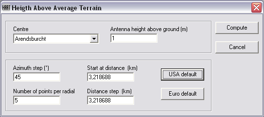
Centre
Select the unit to be centre of the calculation.
Antenna height above ground (m)
Antenna height above ground in meters for this calculation.
Settings for HAAT calculation
Azimuth step
The step in degrees at which radials have to be used.
Start at distance (Km)
The distance at the radial calculated from the centre unit at which the first height must be determinated.
Number of points per radial
Number of heights taken at the radial. It sets the maximum ditance at which ground heigth wil be measured. This is Start distance + ( number of points x distance)
Distance step (Km)
It produces a result as displayed below:
[USA Default] button and [Euro Default] button
These buttons preset all settings to defaults:
| Default values |
USA |
Euro |
| Azimuth step |
45 |
10 |
| Start at distance (Km) |
3 |
5 |
| Number of points per radial |
51 |
3 |
| Distance step (Km) |
0,26 |
3 |
Compute
Compute HAAT. After calculation Notapad will be opened and present the file Haat.txt with the calculation results.
Cancel
Cancel operation.
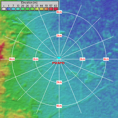
Explanation
For unit 'PI2APD' HAAT is calculated. In this example the following settings are used for explanation:
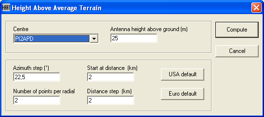
As a result of this at 16 radials at a distance of 2 and 4 km (start is 2 Km, and step is 2 Km) ground height is determinated from DEM. Using 'Draw rings' the points that are calculated are displayed in the following image.
After calculation the following file is opened:
| Haat.txt |
Height Above Average Terrain
Report generated at 21:42:31 , 4-8-2011
------------------------------------------------------------
Antenna geographic coordinates
52°13'11"N,005°59'25"E
JO22XF
Ground elevation: 10,4m
------------------------------------------------------------
Antenna height above ground: 25m
------------------------------------------------------------
Azt(°) D(km) Ground elevation(m)
000 02,00 0005,9
000 04,00 0007,0
000 Average 6,45m
000 HAAT 28,9500015258789m
023 02,00 0004,0
023 04,00 0003,0
023 Average 3,5m
023 HAAT 31,9000015258789m
045 02,00 0007,0
045 04,00 0004,0
045 Average 5,5m
045 HAAT 29,9000015258789m
068 02,00 0008,0
068 04,00 0005,0
068 Average 6,5m
068 HAAT 28,9000015258789m
090 02,00 0007,0
090 04,00 0005,0
090 Average 6m
090 HAAT 29,4000015258789m
113 02,00 0010,0
113 04,00 0009,9
113 Average 9,95m
113 HAAT 25,4500015258789m
135 02,00 0018,0
135 04,00 0007,0
135 Average 12,5m
135 HAAT 22,9000015258789m
158 02,00 0012,0
158 04,00 0012,1
158 Average 12,05m
158 HAAT 23,3500015258789m
180 02,00 0015,5
180 04,00 0018,0
180 Average 16,75m
180 HAAT 18,6500015258789m
203 02,00 0014,4
203 04,00 0021,0
203 Average 17,7m
203 HAAT 17,7000015258789m
225 02,00 0016,0
225 04,00 0023,0
225 Average 19,5m
225 HAAT 15,9000015258789m
248 02,00 0018,0
248 04,00 0025,4
248 Average 21,7m
248 HAAT 13,7000015258789m
270 02,00 0020,5
270 04,00 0036,0
270 Average 28,25m
270 HAAT 7,15000152587891m
293 02,00 0022,1
293 04,00 0034,3
293 Average 28,2m
293 HAAT 7,20000152587891m
315 02,00 0013,0
315 04,00 0023,2
315 Average 18,1m
315 HAAT 17,3000015258789m
338 02,00 0010,0
338 04,00 0010,4
338 Average 10,2m
338 HAAT 25,2000015258789m
------------------------------------------------------------
Antenna elevation above sea level : 35,4m
Average ground elevation above sea level: 13,93m
------------------------------------------------------------
HAAT: 21,4700015258789m
|
|
