|
Radio Mobile - RF propagation simulation software |
|
|
|
|
|
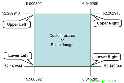
Inside the .inf file are the geographical coordinates of the upper left and lower right corners and a title for the image map.
File location:
The location of the file is not mandatory as long as it is in the same folder with the raster image file.
| mapfile.in |
< Longitude1>,[space] < Latitude1>
< Longitude2>,[space] < Latitude2>
< Name>[space],[space]< Filename> |
Variables:
| Variable |
Comment |
| Longitude1 |
Longitude in degrees.minutes.seconds(N/S) of the 1st point in the raster image. |
| Latitude1 |
Latitude in degrees.minutes.seconds(W/E) of the 1st point in the raster image. |
| Longitude2 |
Longitude in degrees.minutes.seconds(N/S) of the 2nd point in the raster image. |
| Latitude2 |
Latitude in degrees.minutes.seconds(W/E) of the 2nd point in the raster image. |
| Name |
the text "Radio Mobile" |
| file name |
the first 15 characters of the raster image filename. |
Sample file:
| mapfile.inf |
53.56.40N, 003.20.68E
50.20.41N, 007.12.86E
Radio Mobile - 20070927_JOTACo |
|
|
| |
|
|
cmsimple-styles.com template modified by PE1MEW |
